Arnhall Castle
Arnhall Castle Details
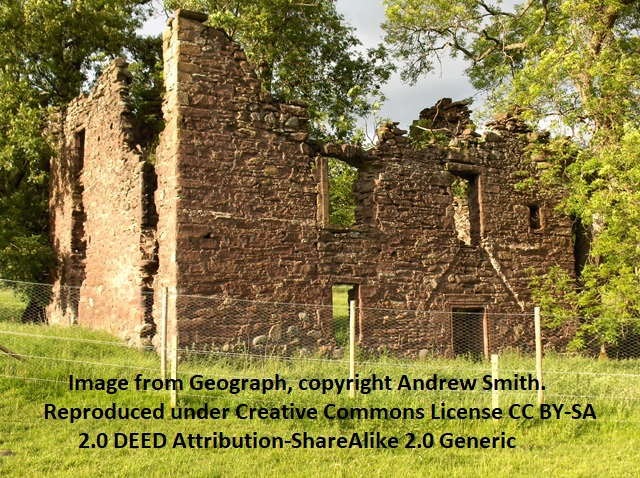
Arnhall Castle, ruins of C17 tower house on private estate land
- Closest To: Dunblane, Bridge of Allan, Doune
- Access: S.O.A.C. Public Access
- Grid Reference: NS763986
Arnhall Castle is a ruined tower house dating most likely to the early 17th century and lying within the estate of Keir House. The tower house was L-shaped, with a courtyard to the rear that was converted to agricultural use. The two walls that overlooked the entrance have fallen entirely, and the rest survives to the wallhead, but seems to be in poor condition. It is surrounded by wire fencing for safety reasons. Not to be confused with Arnhall House in the Mearns, which was a Dow property, (split between three heiresses in 1697 one of whom was married to a member of the Murrays of Atholl) this appears to have been part of the estate of the Stirlings of Keir, who acquired that estate from the Leslie family in two parts during the mid 15th century. The history of the Stirlings of Keir is well-recorded, but it is interesting to note that the name Arnhall does not appear once in the primary source for that family history, and it is clearly shown as being separate from the house of Keir in early maps, even Roys map showing it with a separate driveway from the military road between Perth and Fort William. Craigarnhall (previously Craigarnot) did not belong to the Stirlings and is shown as separate again throughout. The house of Arnhall continues to be shown on maps up to that of Thomson in 1827, but the layout and named properties do not seem to have been updated since 1782.
According to the 1902 “Ancient castles and mansions of Stirling nobility” by JS Fleming, there was a datestone on the building marked 1617 – but the same book describes the tower as having been square, and makes the inaccurate link with the Atholls through one Harry Dow of Arnehall’s 1647 grant to the church in Stirling. It does, however, have a useful illustration by the author. Unfortunately neither of the Statistical Accounts makes reference to Arnhall, and the only mention of a Dow in the Stirlings of Keir is Patrick Dow, a witness to a 1514 charter. Harry Dow of Arnehall appears to have been married to Helen Stirling, a granddaughter of the Stirling laird of Keir, and in 1649 the land tax rolls record John Dow of Arnhall “for Easter Row, Newbiggings, and Cottreys” valued at £310. Farther down, Archibald Stirling of Keir is valued for Arnhall at the same amount, suggesting that John Dow was his tenant. Beyond this it is hard to make any comment. It is a confusing and frustrating history, perhaps only to be clarified if the Keir estate has old maps not in the public domain.
Become a supporter of my work to access a more detailed history