Ardgowan Castle
Ardgowan Castle Details
Ardgowan Castle, unoccupied and private C15 tower of the Stewarts abandoned C18 in favour opf new mansion; restored C19
- Closest To: Inverkip, Wemyss Bay, Gourock
- Access: S.O.A.C. Public Access
- Grid Reference: NS205728
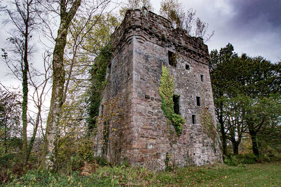
Ardgowan Castle is a modest tower which is dated to the 15th century. It retains its roof but is not inhabited, and is kept locked up for security reasons. It lies within the grounds of Ardgowan House, which do have a number of footpaths running through them, one of which runs past the tower. These are open for the public to walk along and shown on the Ardgowan estate website. Ardgowan House lies across the width of a steep sided triangular promontory, and the tower occupies a site towards the narrowest point at the south-western end. The location is strongly defensive, and it is likely that the promontory was fortified from an early date. The lands of Inverkip (the earlier name for the castle) were part of the Stewart lordship of Renfrew, and during the late 13th century there was a fortification here, although any details about what it was like are unknown. This castle was taken by English forces (including the future King Robert Bruce) in 1303, and became an important supply base for the English forces. It was at Inverkip that a “great engine” was manufactured in preparation for the siege of Stirling Castle in 1304, and which Robert Bruce reported he was struggling to find transport for. After Bruce murdered John Comyn in Dumfries in 1306, forces loyal to him attacked the castle here, but the attack was unsuccessful; Thomas Randolph was imprisoned here in 1307, and Philip Mowbray fled here whilst in English employ.
The castle was probably destroyed in the wars that followed, given its importance to the English war effort, and next appears in the reign of Robert III, when the lands of Ardgowan, Blackhall and Auchingowan were granted to his illegitimate son John Stewart, sheriff of Bute. – Ardgowan was granted in 1403. A father-son succession followed – John (II) in 1412, John (III) in 1442, John (IV) in 1445, John (V) in 1493, and John (VI) in 1513. John (VI) was followed by James as 6th laird, James by a second James in 1553, and a third James in 1579. Then we revert back to John, who died in 1598, and was succeeded by his younger brother Archibald. It was the third James who obtained a charter for his lands as a free barony in 1576, and John who held Ardgowan when the Pont map was drawn up. This map shows a more considerable tower house than survives today at Ardgowan, seemingly an L-plan tower with a courtyard. LIDAR imagery does seem to suggest two ditches cross the promontory to the north-east of the tower, as well as a small ditch near the tower, but what this represents is unclear. The tower, which was much repaired in the 19th century, and a second time in 1936, is entered at first floor level, has a vaulted basement lit by a single inverted keyhole style gunloop (potentially mid 15th century) presumably reached by an internal stair. A heraldic panel is overgrown by ivy and cannot now be seen. The offsetting of small windows in the north-west gable suggests that the staircase is in this corner and served all floors. The first floor is lit by a window looking south-west (and a matching gunloop), a single window overlooking the cliff to the south-east, a single window facing north-east, and two facing north-west over the courtyard. The second floor is lit by a single window above the entrance door, one above that overlooking the cliff, a central window facing north-east, and again two overlooking the courtyard. Three of the corners display corbelling for open round bartizans (not above the doorway) and a stub of masonry by the gunloop may represent the location of either the barmkin wall – or a now lost portion of the tower. By 1750, when General Roy drew his map, Ardgowan is depicted as an L-plan building, with a walled courtyard to the west. It is clear, therefore, that the consolidation of the tower has hidden much of relevance to understanding it, perhaps documentation held by the estate could clarify this, but if so, it is not generally available to the public. John Stewart’s descendants still hold the lands and estate today, having founded the new mansion in 1798.
Become a supporter of my work to access a more detailed history