Aithernie Castle
Aithernie Castle Details
Aithernie Castle, ruins of C16/17 tower house of the Carmichaels, Inglises, Riggses and Watsons, ruined by early C19
- Closest To: Leven, Kennoway, Methil, Largo
- Access: S.O.A.C. Public Access
- Grid Reference: NO380357
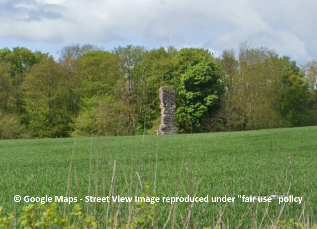
Aithernie Castle is the fragmentary ruin of a tower house consisting primarily of one corner, which stands to the height of four storeys, fenced off in the middle of a field which overlooks the Scoonie Burn north of Leven. The masonry can clearly be seen from the road, but is partially hidden by the dipping slope to the burn. The lands were held by Stephen de Aithernie in the reign of King David I, and by 1220 it had passed to the Lundin family, who held the estate from the Earls of Fife. They appear to have been lost during the Wars of Independence as they opposed Robert Bruce, and in 1479 King James III confirmed grants made “by our predecessors” to the bishop and church of St Andrews, which included those of Aithernie. Later documentation shows that Aithernie was then granted to the Nunnery of North Berwick before 1536, as in that year the feu was ranted by the Abbess to John Carmichael, an Edinburgh burgess.
The ruin is the north-eastern corner of the building, and shows no signs of vaulting, the ground floor instead having three joist holes in the north wall. The return in the masonry at the southeastern point shows that there was a ground floor entrance here, with masonry above suggesting a window immediately above. The ground floor walls contain red sandstone rubble, but none of the rest of the remains contain this stone, suggesting more than one build date. There is a window return at the northwestern end of the second floor, together with a single joist hole to its east, and a further window return at the third floor level above the putative doorway. A small stub of masonry extending northwards from the external angle is likely to represent the barmkin wall, but there is no evidence in the contours or available cropmarks to suggest the extent of this – or indeed the extent of the tower itself.
The lands were inherited by his son Richard, who died in 1588, and then passed into the hands of another Edinburgh burgess, Thomas Inglis, perhaps by marriage. At the Reformation, the superiority of the lands had passed to Alexander Home, the Nunnery being made into a lay barony. Aithernie then passed by marriage to William Rigg, who married Sarah Inglis, and in about 1644 to their son Thomas. In 1670 this Thomas, or his son (a second Thomas Rigg) sold Aithernie to James Watson of Downfield, who disponed it to his son Alexander in 1692. In the 1720s, Alexander (and for a while his son David, who may have predeceased him) was outlawed, and Aithernie may have been held by his daughter Anne as a result, with her husband James Smyth, although title passed to them when Smyth purchased the property from the creditors in 1735. Their daughter Margaret married Dr Thomas Carmichael, and their son James sold Aithernie after 1796. In the mid 18th century, General Roy’s map shows Aithernie as occupied and the centre of some formal grounds, as does that of John Ainslie in 1775, reproduced in 1801. However the castle was described by Sir Robert Sibbald as “a fine house with gardens, orchards and parks” in the main text of his History, (dated 1710) and then in a footnote “The property of Sir William Erskine, Bart. and is now in ruins” from the 1803 reprint. It is labelled “Aithernie Ruins” on John Dowers map of 1828. This tells us that the castle fell into ruins between 1775 and 1803.
Become a supporter of my work to access a more detailed history