Barclosh Castle
Barclosh Castle Details
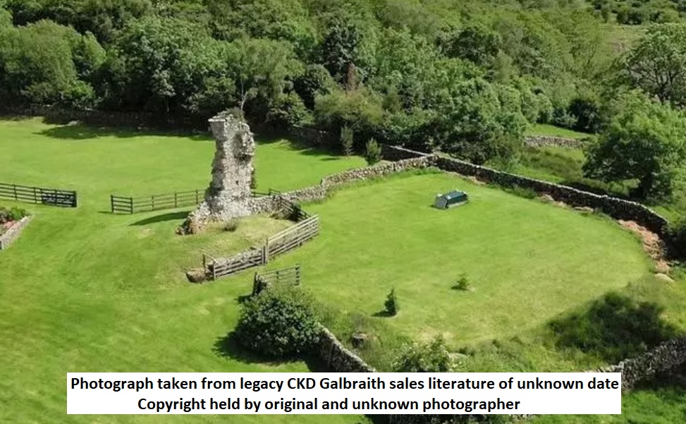
Barclosh Castle, ruins of ?C16 tower of the Herres, and later Maxwell, families built into field wall
- Closest To: Dalbeattie
- Access: S.O.A.C. Public Access
- Grid Reference: NX854624
Barclosh Castle is a ruined tower house sat on slopes overlooking the Kirkgunzeon Lane (a watercourse) to the west upstream of Dalbeattie, where it joins the Urr Water. The ruin sits within the confines of a working farmyard, and cannot be seen from public roads.
The lands of Barclosh were part of the larger lands of Kirkgunzeon leased to Holm Cultran Abbey by Uhtred, Lord of Galloway, in about 1170. The abbey continued to pay its dues to subsequent Lords of Galloway, including Balliols and Douglases, into the 1360s, when King David II rewarded a major Douglas retainer, Sir John Heryz, with lands formerly belonging to Holm – at this point in enemy territory. There was a condition that the monks should be compensated for any loss, but whether this was followed or not is unknown!
Although the 4th Lord Herries, Sir John Maxwell, built several towers in his lands, it was not until after the 1590s that a tower was founded at Barclosh. The nature of this tower is not entirely clear, as only one corner of the tower stands today, the south-east corner, and the major part of that is the gable end. It all sits on an irregular mound, which seems likely to be demolition debris, although now grassed over. The first Ordnance Survey shows that in the mid 19th century, the east gable was traceable, and that much of the north wall survived – but the west gable and part of the south wall had gone. This shows that the tower measured perhaps 7 or 8 metres wide and at least that long. The First Statistical Account does not say that Barclosh was ruined, stating that it was believed to be “one of the seats of the family of Herries, but there are no records when it was built; it seems to have been a place of refuge, defended more by nature than by art, being remote and inaccessible” – which reflects late 18th century thought rather than anything of real value. An estate map of 1775 does not show the tower, which was presumably in ruins by that date, and the 1795 Ainslie map states that it was ruined. The tower seems to have had three storeys and an attic level, judging from the remaining traces of the roofline, and as such was a tower house – albeit perhaps a modest one. We might therefore draw the conclusion that the entrance and an internal winding stair were in the south-west corner, and perhaps infer that any barmkin courtyard were this side. The estate as a whole remained in the hands of the Maxwells and their descendants into the 20th century; presumably the ruined tower made a good source of stone for farm buildings.
Become a supporter of my work to access a more detailed history